
How to Distinguish
- Domains may also use .ru and .su (country code top-level domain for the USSR)
- Crosswalk signs have three lines.
- The numbers on the signs by the side of the road indicate the distance between the start and end points.
- They are also gas stations and bank lines for Gazprom, the world's largest producer of natural gas. If there is a building with a blue or dark blue logo and the sign "Газпром", it is probably Russian.
- Pipes often run over walls, fences, etc.(by now_and_jenn )
Signs you can find


Gazprom is the world’s largest producer and supplier of natural gas and is a Russian state-owned company. Nord Stream is also a major shareholder in Gazprom.
Crosswalk signs have three lines painted on them, and there are signs with distances written on the side of the road. The distances written on the signs are often quite long.
Pipes are stretched along the fence.
Narrow down state/region
- Need to determine plant distribution and dominant tree species by region
- Japanese butterbur・Petasites japonicus growing in Sakhalin.(by sound_of_silence_wl )
- Many trees with needle-like leaves around Magadan (not sure what kind of trees)(by niwaisound )
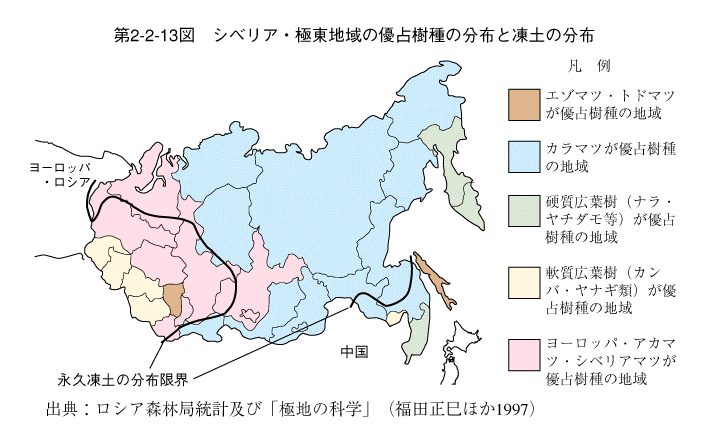
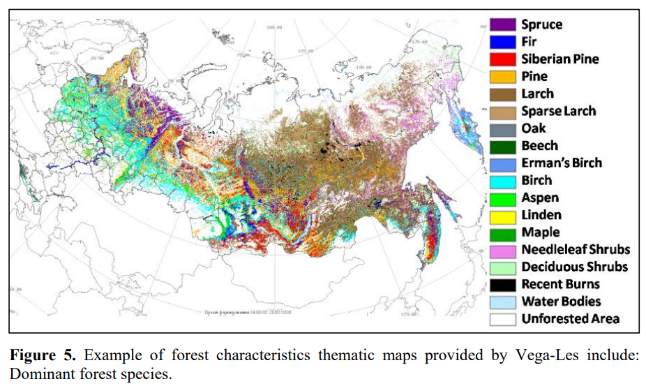
Density of larch (brown area in the figure below) varies from place to place
Birch is an important clue because it’s easy to see and understand.
Butterbur grows throughout Japan and in Sakhalin.
Spruce is abundant near and west of the northwestern mountains.
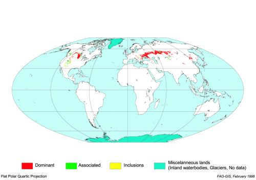
- There is blackish fertile soil (chernozem) from Ukraine to southern Siberia, and grain production is flourishing.
- The road has sand on the side in the central north provinces of Russia. (by sound_of_silence_wl )
- Astrakhan soil. (by sound_of_silence_wl )
Chernozem is distributed in the red area (image from the United Nations, public domain).
The soil around Astrakhan is red and sparsely vegetated, so it is not difficult to identify.
It seemed to be blackish, but I don’t know if it has any characteristics.
- Kamchatka volcano. (by sound_of_silence_wl )
- A lot of fog in sakha republic. (by sound_of_silence_wl )
- If the percentage of right-hand drive Japanese cars is too high, the eastern coast may be closer(References 日本の中古車天国ウラジオストク、対露制裁後の変化 現地社長に聞く日本車需要の展望)?
- You can narrow down the area by looking at the phone numbers, the first number in the area code from west to east is 4-8-3-4.(by Geotips )
Federal Subjects of Russia (85)
Try the quiz- Saint Petersburg
- Moscow首都
- Jewish Autonomous Oblast
- Chukotka Autonomous Okrug
- Yamalo-Nenets Autonomous Okrug
- Nenets Autonomous Okrug
- Khanty-Mansi Autonomous Okrug
- Altai Republic
- Karachay-Cherkessia
- Kabardino-Balkaria
- North Ossetia
- Ingushetia
- Chechnya
- Dagestan
- Karelia
- Buryatia
- Tuva
- Sakha (Yakutia)
- Kalmykia
- Bashkortostan
- Tatarstan
- Khakassia
- Mordovia
- Chuvashia
- Mari El
- Udmurtia
- Komi
- Adygea
- Pskov Oblast
- Krasnodar Krai
- Murmansk Oblast
- Leningrad Oblast
- Kaliningrad Oblast
- Smolensk Oblast
- Bryansk Oblast
- Kursk Oblast
- Belgorod Oblast
- Voronezh Oblast
- Rostov Oblast
- Zabaykalsky Krai
- Amur Oblast
- Khabarovsk Krai
- Primorsky Krai
- Tyumen Oblast
- Kurgan Oblast
- Omsk Oblast
- Novosibirsk Oblast
- Chelyabinsk Oblast
- Altai Krai
- Orenburg Oblast
- Saratov Oblast
- Astrakhan Oblast
- Volgograd Oblast
- Crimeaロシアが実効支配(国際的には係争中)
- Magadan Oblast
- Sakhalin Oblast
- Sevastopolロシアが実効支配(国際的には係争中)
- Arkhangelsk Oblast
- Krasnoyarsk Krai
- Kamchatka Krai
- Sverdlovsk Oblast
- Lipetsk Oblast
- Tambov Oblast
- Tomsk Oblast
- Ulyanovsk Oblast
- Penza Oblast
- Kemerovo Oblast
- Oryol Oblast
- Irkutsk Oblast
- Kaluga Oblast
- Kostroma Oblast
- Yaroslavl Oblast
- Vladimir Oblast
- Ryazan Oblast
- Ivanovo Oblast
- Nizhny Novgorod Oblast
- Tula Oblast
- Vologda Oblast
- Novgorod Oblast
- Tver Oblast
- Moscow Oblast
- Kirov Oblast
- Perm Krai
- Samara Oblast
- Stavropol Krai