SpainMainland

clues 32Regions 15Updated 2023-07-01

Quiz ▾Basics ▾Companies ▾

LanguageSpanish
Driving sideDrives on the right
Domain.es
Camera gensGen 2–4Small Cam, Bad Cam

Whole area11

Clues that work anywhere in this area

Language & Script★★★

"CALLE" on a street sign is Spanish for street. In Catalan-speaking areas it may read "CARRER" instead.

Examples1SourcesFree Software Street
Includes a Free Software Street sign found in Catalonia
Signs★★★

Signs are often mounted on thin, rectangular iron pipes.

Examples1234
Signs★★★

You'll find both black-and-white and blue-and-white chevrons. If a chevron is black-and-white and the sign or chevron post is a square rectangle, Spain or Andorra is worth considering.

Watch outPortugal uses a yellow arrow on black. The only other country using blue-and-white chevrons is France, while black-with-white chevrons appear in the UK and countries around Italy.
Examples1SourcesMap of European Road Curve Chevron SignsSee alsoPortugalFranceUnited KingdomAndorra
Bollard★★★

Like the postboxes, bollards are also yellow, sometimes with yellow reflectors. Occasionally you'll see a slightly different-looking one.

Watch outSimilar-looking bollards occasionally appear in Chile and in Argentina's Jujuy province too, so don't lock in a guess from the bollards alone.1
Examples123See alsoChileJujuy Province, ArgentinaBelgiumAndorra
Road★★★

Small orange or yellow signs beside the road often show a road number.

Examples12
Road★★★

Road lines are mostly white, though occasionally yellow.

Building★★★

French tiles (F-shape) and Spanish tiles (S-shape) are made the same way, but French tiles are flat while Spanish tiles are half-round (unconfirmed).

Narrowing down the region18

Once you know the area: which part of it

Language

Language & Script★★★

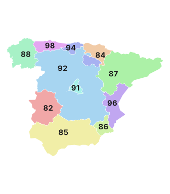
Language varies by region, and street-sign spelling can help narrow it down. The most common street-name word is "CALLE".

  • East: Catalan. Streets read "CARRER"
  • West: Galician. Streets read "RÚA"
  • Part of the north: Basque. Streets read "KALEA"
Where
Castilla-LeonCataluñaMurciaLa RiojaCantabriaAndaluciaAsturiasValenciaNavarraGaliciaAragonMadridExtremaduraCastilla-La ManchaPais Vasco
Road★★★

Ring road and highway numbers often begin with letters identifying the city — "BI", for instance, means near Bilbao.

Vegetation

Castilla-LeonCataluñaMurciaLa RiojaCantabriaAndaluciaAsturiasValenciaNavarraGaliciaAragonMadridExtremaduraCastilla-La ManchaPais Vasco

Where Vegetation clues apply4

Click an item to jump to its clueTap to show the range; tap again or → to jump to the clue

  1. dehesa
  2. eucalyptus
  3. Pinus pinea
  4. Aleppo pine
Plants & farming★★★★★

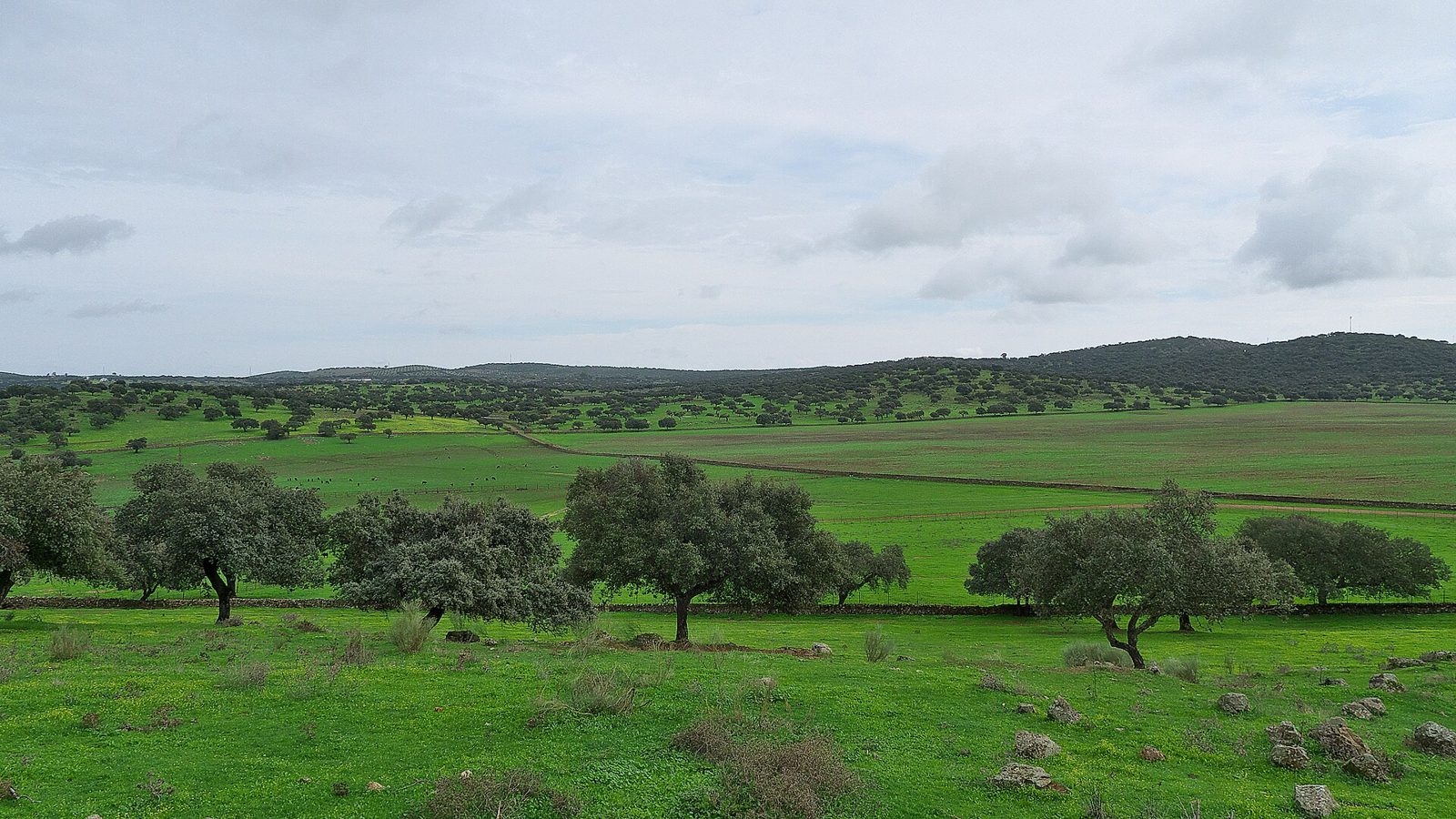
Low oak trees dotting grassland at spacing that keeps them from touching, with cattle or pigs grazing beneath — that's dehesa.
Examples12SourcesDehesa - Wikipedia (extent, area, composition)
Where
Castilla-LeonCataluñaMurciaLa RiojaCantabriaAndaluciaAsturiasValenciaNavarraGaliciaAragonMadridExtremaduraCastilla-La ManchaPais Vasco
Dehesa with oaks scattered across grassland (Badajoz province)
José Luis Filpo Cabana / CC BY 3.0
Plants & farming★★★★

Plantations of tall, straight-trunked trees with whitish bark peeling off in long strips and drooping leaves are eucalyptus. Most common in Galicia in the northwest, and also common along the coasts of Cantabria and Asturias.

SourcesGreenpeace España — La conflictividad de las plantaciones de eucalipto en España (area by region)El Debate — El inventario forestal de Galicia contabiliza 438.156 hectáreas de eucalipto en 2024
Where
Castilla-LeonCataluñaMurciaLa RiojaCantabriaAndaluciaAsturiasValenciaNavarraGaliciaAragonMadridExtremaduraCastilla-La ManchaPais Vasco
Plants & farming★★★

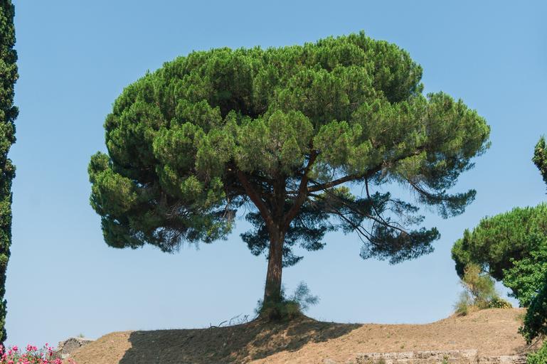
The tree Pinus pinea has an uneven distribution, most common in southwestern Andalucía (Huelva and Córdoba provinces). There are also sizeable stands in Valladolid province in the centre and along the Catalan coast.

Examples12SourcesAproximación al sector del piñón en España (MAPA, area by province)Map Pinus pineaCategory:SVG flora distribution maps
Where
Castilla-LeonCataluñaMurciaLa RiojaCantabriaAndaluciaAsturiasValenciaNavarraGaliciaAragonMadridExtremaduraCastilla-La ManchaPais Vasco
Distribution of Pinus pinea
By Original: Roke (Blank_Map_of_Europe_-w_boundaries.svg) Derivative work: Carnby - This file was derived from: Blank Map of Europe -w boundaries.svg: Polunin, O., Walters, M. (1985). A Guide to the Vegetation of Britain and Europe. Oxford University Press. p. 115., CC BY-SA 3.0
Plants & farming★★★

The Aleppo pine — the sort you'd expect to see near Marseille — is found only in the eastern half of Spain, especially near the sea. It's also common on offshore islands like the Balearics.

Examples12SourcesMITECO — Pinus halepensis (area by region)See alsoBalearic Islands
Where
Castilla-LeonCataluñaMurciaLa RiojaCantabriaAndaluciaAsturiasValenciaNavarraGaliciaAragonMadridExtremaduraCastilla-La ManchaPais Vasco

Agriculture

Castilla-LeonCataluñaMurciaLa RiojaCantabriaAndaluciaAsturiasValenciaNavarraGaliciaAragonMadridExtremaduraCastilla-La ManchaPais Vasco
Castilla-LeonCataluñaMurciaLa RiojaCantabriaAndaluciaAsturiasValenciaNavarraGaliciaAragonMadridExtremaduraCastilla-La ManchaPais VascoCampo de Dalías (around El Ejido)Around Níjar
Castilla-LeonCataluñaMurciaLa RiojaCantabriaAndaluciaAsturiasValenciaNavarraGaliciaAragonMadridExtremaduraCastilla-La ManchaPais VascoSevillaExtremadura (Vegas del Guadiana)Ebro DeltaValenciaSevillaExtremadura (Vegas del Guadiana)Ebro DeltaValencia
Castilla-LeonCataluñaMurciaLa RiojaCantabriaAndaluciaAsturiasValenciaNavarraGaliciaAragonMadridExtremaduraCastilla-La ManchaPais Vasco

Where Agriculture clues apply6

Click an item to jump to its clueTap to show the range; tap again or → to jump to the clue

  1. olive
  2. orange
  3. vineyard
  4. plastic greenhouse
  5. rice paddy
  6. wheat field
Plants & farming★★★★★

Low trees planted at even intervals right up a hillside are an olive grove. If it's all olives to the horizon, you're in inland Andalucía.
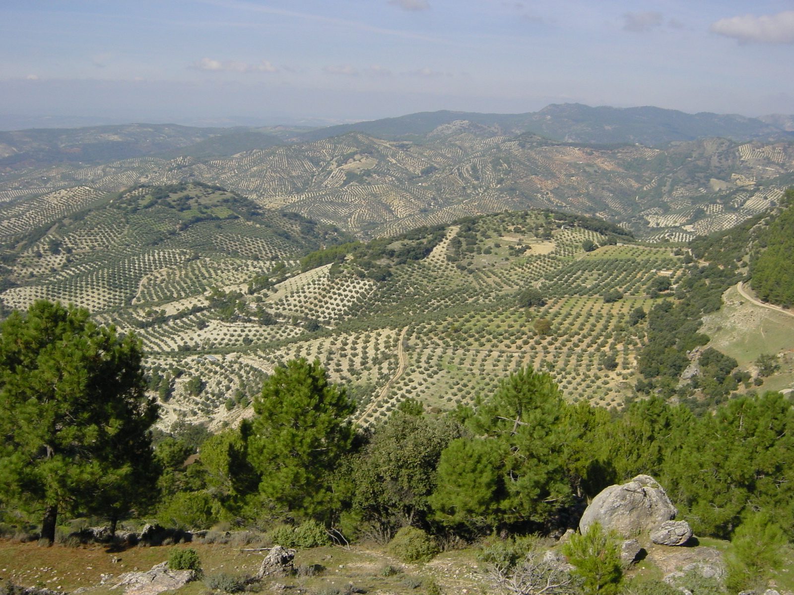
Examples123SourcesOlive oil - Wikipedia (share by country and region)MAPA — ESYRCE 2024 olivar (area by region)
Where
Castilla-LeonCataluñaMurciaLa RiojaCantabriaAndaluciaAsturiasValenciaNavarraGaliciaAragonMadridExtremaduraCastilla-La ManchaPais Vasco
Olive groves blanketing the hillsides (Jaén province)
Allie_Caulfield / CC BY 2.0
Plants & farming★★★★

An orchard of low, dark green evergreen trees planted in neat rows, with irrigation channels running around the fields, is an orange grove. Valencia accounts for about half of Spain's citrus fields.
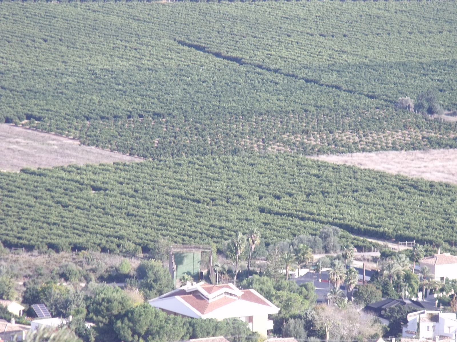
Examples12SourcesValencian Community - Wikipedia (citrus growing regions)La superficie de cítricos según la Encuesta Esyrce (MAPA ESYRCE 2023 area by region)
Where
Castilla-LeonCataluñaMurciaLa RiojaCantabriaAndaluciaAsturiasValenciaNavarraGaliciaAragonMadridExtremaduraCastilla-La ManchaPais Vasco
Orange groves covering a hillside (Valencia province)
B25es / CC BY-SA 3.0
Plants & farming★★★★

Low-trained grapevines lined up in perfect order to the horizon, on flat, dry land — that's Castilla-La Mancha. Among the largest vineyards in Europe.
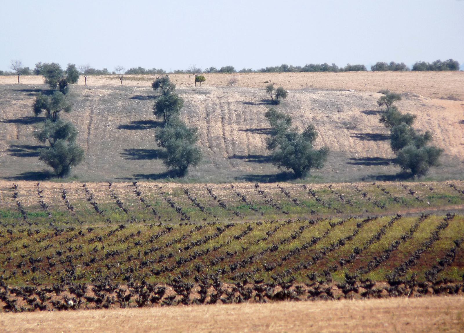
Examples12SourcesCastilla–La Mancha - Wikipedia (land use and area)La Gaceta del Vino — España pierde casi 17.500 hectáreas de viñedo en 2024 (MAPA area by region)
Where
Castilla-LeonCataluñaMurciaLa RiojaCantabriaAndaluciaAsturiasValenciaNavarraGaliciaAragonMadridExtremaduraCastilla-La ManchaPais Vasco
Rows of grapevines mixed with olives on dry soil (Castilla-La Mancha)
michael clarke stuff / CC BY-SA 2.0
Plants & farming★★★

Greenhouse farming thrives in Almería province — the white patches near the southeastern coast in particular are packed with plastic greenhouses.

Examples12SourcesAlmería provincePlasticulture - Wikipedia (greenhouses of Campo de Dalías and Níjar)
Where
Castilla-LeonCataluñaMurciaLa RiojaCantabriaAndaluciaAsturiasValenciaNavarraGaliciaAragonMadridExtremaduraCastilla-La ManchaPais VascoCampo de Dalías (around El Ejido)Around Níjar
  • Campo de Dalías (around El Ejido)
  • Around Níjar
Plants & farming★★★

Rice production is almost entirely confined to the well-watered regions of Sevilla, Extremadura, the Ebro Delta, and Valencia — rice paddies are hard to find anywhere else.
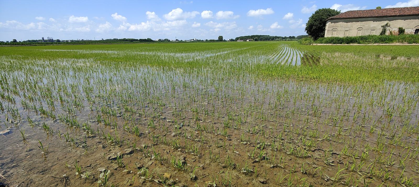
  • Sevilla (the Guadalquivir River wetlands)
  • Extremadura (along the Guadiana River)
  • Ebro Delta
  • Valencia
Examples123456SourcesEuropean Rice Cropland Mapping with Sentinel-1 Data: The Mediterranean Region Case StudyMAPA — La producción de arroz se recupera (2024, main producing regions)
Where
Castilla-LeonCataluñaMurciaLa RiojaCantabriaAndaluciaAsturiasValenciaNavarraGaliciaAragonMadridExtremaduraCastilla-La ManchaPais VascoSevillaExtremadura (Vegas del Guadiana)Ebro DeltaValenciaSevillaExtremadura (Vegas del Guadiana)Ebro DeltaValencia
Flooded, level rice paddies (photo is from Vercelli, Italy)
Al*from*Lig / CC BY-SA 4.0
Plants & farming★★★

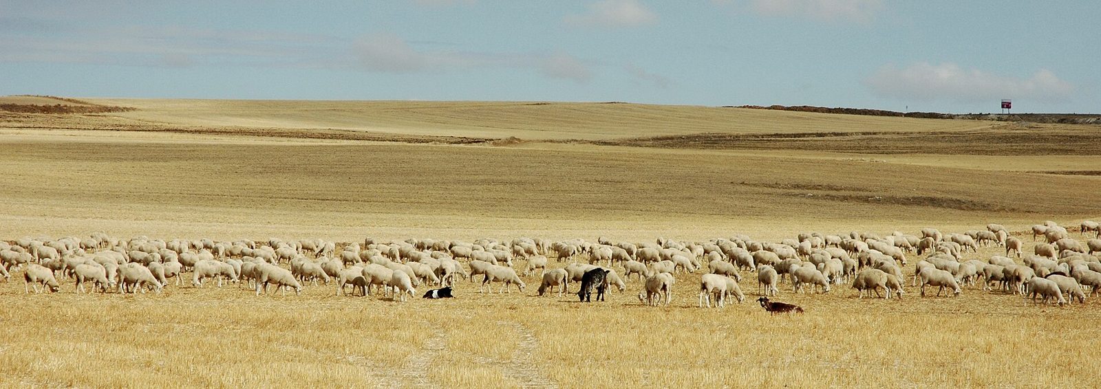
A gently rolling plateau of wheat fields — green in early summer, golden in summer — stretching to the horizon, with almost no trees or fences, means the northern Meseta (Castilla y León). It's known as "Spain's breadbasket".
Examples12SourcesAgronews — Castilla y León acapara el 32,6% de la superficie de cereales (MAPA 2013)Agronews — Radiografía de la agricultura española por comunidades autónomas (FEGA 2018)
Where
Castilla-LeonCataluñaMurciaLa RiojaCantabriaAndaluciaAsturiasValenciaNavarraGaliciaAragonMadridExtremaduraCastilla-La ManchaPais Vasco
Flat, treeless wheat stubble with a flock of sheep (photo is from the Spanish Meseta)
Ruud Zwart / CC BY-SA 2.5 nl

Industry & Resources

Castilla-LeonCataluñaMurciaLa RiojaCantabriaAndaluciaAsturiasValenciaNavarraGaliciaAragonMadridExtremaduraCastilla-La ManchaPais Vasco

Where Industry & Resources clues apply2

Click an item to jump to its clueTap to show the range; tap again or → to jump to the clue

  1. solar power
  2. wind power
Landscape★★★

The sunny southern half of the country has many solar power installations. Besides solar panels, you may also spot tower- or trough-type concentrated solar plants.

Examples1234SourcesRed Eléctrica — Solar fotovoltaica 2024 (installed capacity by region)
Where
Castilla-LeonCataluñaMurciaLa RiojaCantabriaAndaluciaAsturiasValenciaNavarraGaliciaAragonMadridExtremaduraCastilla-La ManchaPais Vasco
Landscape★★★

Dozens of white wind turbines lined up along a ridge or plateau top suggest places like northern Castilla y León or Aragón. There are almost none along the northern coast in Cantabria, or in Madrid.

SourcesRed Eléctrica — Installed capacity (wind) (installed capacity by region)SmartGridsInfo — La potencia eólica instalada en España supera los 31 GW
Where
Castilla-LeonCataluñaMurciaLa RiojaCantabriaAndaluciaAsturiasValenciaNavarraGaliciaAragonMadridExtremaduraCastilla-La ManchaPais Vasco

Architecture

Building★★★★★

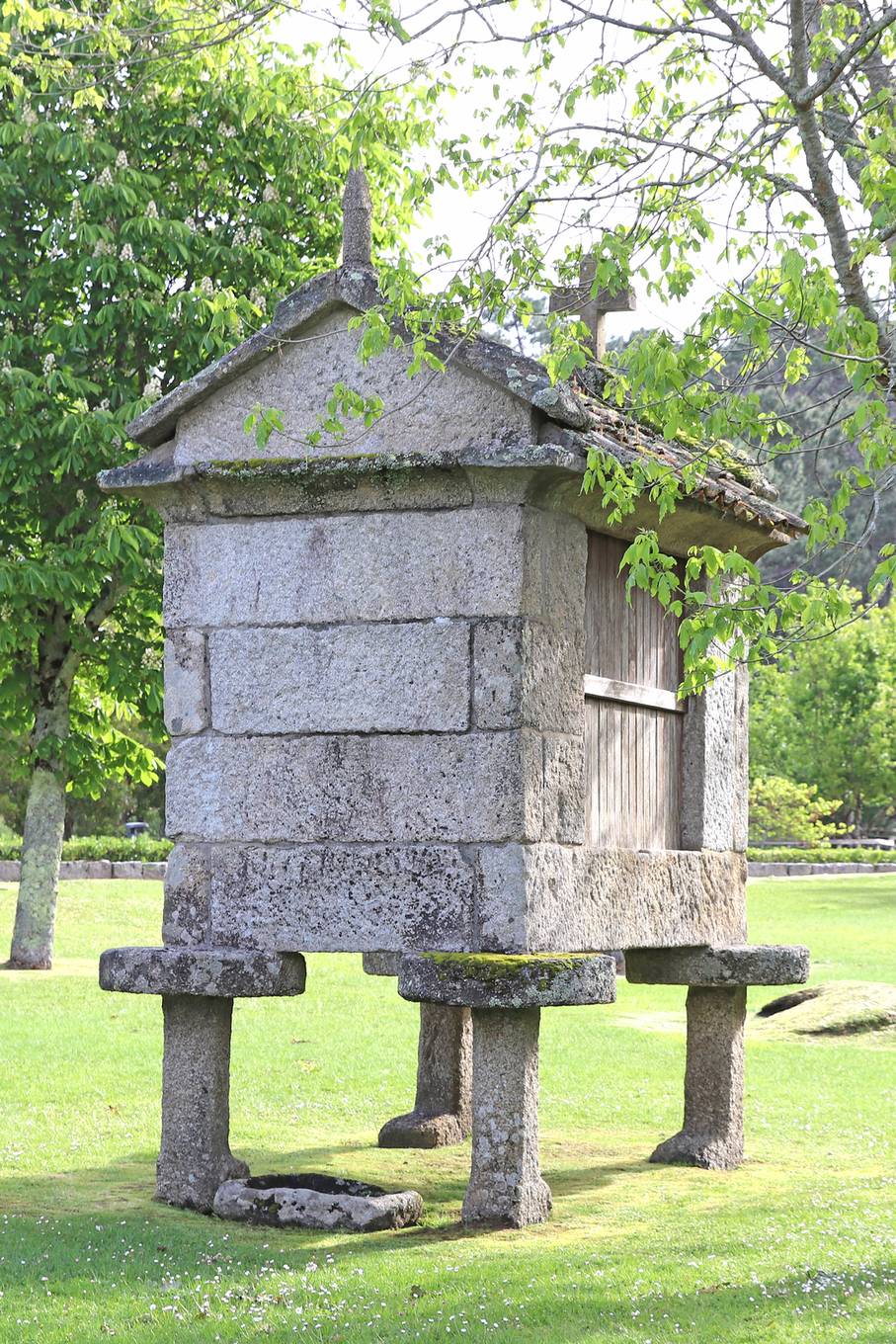
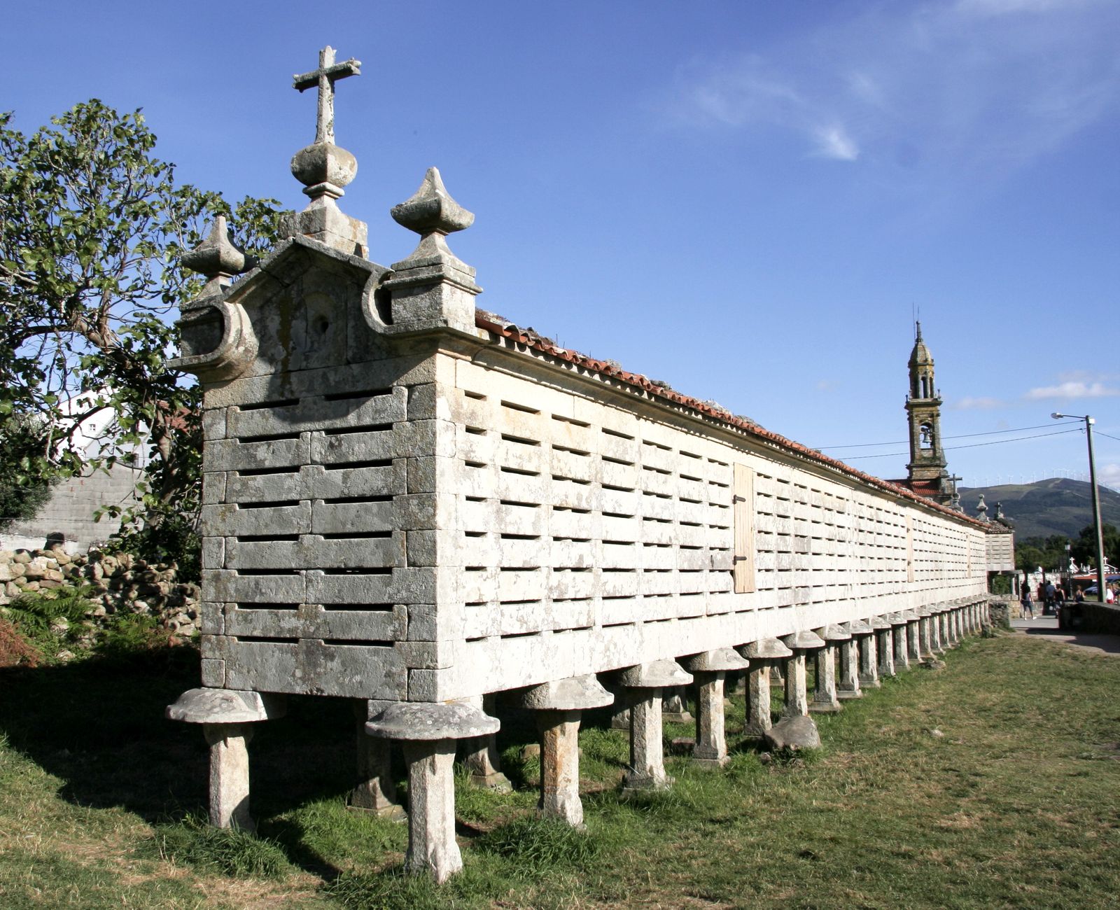
A long, narrow, box-like hut raised on stone posts is a hórreo — a granary protecting grain from damp and rodents, with flat anti-rodent stones wedged onto the tops of the posts. Found mainly in Galicia and Asturias.
Examples12SourcesHórreo - Wikipedia (distribution, count, form)
Where
Castilla-LeonCataluñaMurciaLa RiojaCantabriaAndaluciaAsturiasValenciaNavarraGaliciaAragonMadridExtremaduraCastilla-La ManchaPais Vasco
A hórreo raised on stone posts, with flat anti-rodent stones capping them (Galicia)
Christof46 / CC0
A long, narrow box-shaped hórreo (Carnota, Galicia)
Erik Albers / CC0

Terrain

Landscape★★★

An endless, gently undulating plateau with almost no trees, and mountains visible only far in the distance — that's the interior Meseta (Central Plateau).

Examples12SourcesMeseta Central - Wikipedia (extent and elevation)
Where
Castilla-LeonCataluñaMurciaLa RiojaCantabriaAndaluciaAsturiasValenciaNavarraGaliciaAragonMadridExtremaduraCastilla-La ManchaPais VascoMadrid
Flat, treeless wheat stubble with a flock of sheep (Meseta)
Ruud Zwart / CC BY-SA 2.5 nl

Galicia

Landscape★★★

Galicia and the area near the northern coast are lush and green.

Examples12

Canary Islands

Bollard★★★

Spain's Canary Islands also have the same signs and bollards as mainland Spain.

See alsoCanary Islands

Narrowing down the city3

Once you know the region: which city or town

Picos de Europa National Park

Landscape★★★

Around Picos de Europa National Park, there are villages and roads squeezed between limestone massifs.

Examples123SourcesPicos de Europa National Park
Where
Castilla-LeonCataluñaMurciaLa RiojaCantabriaAndaluciaAsturiasValenciaNavarraGaliciaAragonMadridExtremaduraCastilla-La ManchaPais VascoPicos de Europa National ParkPicos de Europa National Park
De El Jim - https://flic.kr/p/4Kwtmh, CC BY 2.0

Melilla

Landscape★★★

On the north coast of the African continent lies Melilla, one of Spain's autonomous cities.

See alsoMelilla
Where
Castilla-LeonCataluñaMurciaLa RiojaCantabriaAndaluciaAsturiasValenciaNavarraGaliciaAragonMadridExtremaduraCastilla-La ManchaPais VascoMelilla

Ceuta

Landscape★★★

On the north coast of the African continent lies Ceuta, one of Spain's autonomous cities.

See alsoCeuta
Where
Castilla-LeonCataluñaMurciaLa RiojaCantabriaAndaluciaAsturiasValenciaNavarraGaliciaAragonMadridExtremaduraCastilla-La ManchaPais VascoCeuta

Regions

Hover a region on the map to see its name
Castilla-Leon Cataluña Murcia La Rioja Cantabria Andalucia Asturias Valencia Navarra Galicia Aragon Madrid Extremadura Castilla-La Mancha Pais Vasco

Hover a region on the map to see its name

Basics

General facts about this place
  • A passionate country known for flamenco and bullfighting, with many original works of architecture such as Gaudí's Sagrada Família[ref]
  • In addition to Castilian (Spanish), several regional languages are recognized as official, including Catalan, Basque, and Galician[ref]

Companies

Companies with ties to this region. However, this does not necessarily mean they can be used on GeoGuessr.

Logos you may spot

  • BBVA
  • SAN
  • Banco Santander

    -

  • Banco Bilbao Vizcaya Argentaria (BBVA)

    -

Nearby areas

A page of play notes and identification clues for GeoGuessr.